Wind Shear or Tornado - How Do Investigators Decide?
- Mutual Assurance Society
- Mar 24, 2022
- 3 min read
Updated: Mar 28, 2022

Have you ever wondered why the National Weather Service and FEMA take so long to determine if and what size tornado has struck an area? Here is the process they must follow before making a final designation.
Gathering Information
If a tornado strike is suspected anywhere in the U.S., the NWS dispatches a survey team to investigate. Experts carefully examine the type of damage done, reconstruct wind patterns, review satellite and radar imagery, and survey eyewitnesses in their evidence gathering process.
Every survey team is equipped with the technology needed to assess the damage left in the wake of a strong storm. This includes GPS locators, special damage assessment software, satellite imagery, and land surveys. Cell towers in the area may be down, so satellite trucks and equipment are often deployed to make accessing online information possible.
When storm damage covers a large area, teams will often utilize drones to take video of the destruction. The start and endpoints of the storm’s path are determined first, then the width and most heavily damaged areas are identified.
Compiling the Survey
The survey team assigns one of 28 indicators to each type of storm damage they find. Structures and trees are the main categories.
Structures
For structures, "each one of the damage indicators has a description of the typical construction for its category," according to the NWS. "For example, typical construction for one- and two-family residences includes asphalt shingles, tile, slate, or metal roofing, attached single car garage, and brick veneer, wood panels, stucco, vinyl or metal siding." Investigators look for steel beams, concrete blocks, and metal/tar roofing for commercial buildings.
Once these structure indicators are labeled, the survey team determines a degree of damage for each one. The damage categories have upper-end and lower-end of wind speeds which ultimately determine the wind speed range for the storm.
To accurately assign the wind speed range, investigators must know the basics of construction. The quality of construction (whether above, at, or below building codes) affects the accuracy of the survey team's assessments. Poor construction with lower wind speed can result in damage as extensive as good construction and higher wind speeds. Knowing the difference in the materials and fasteners used in building helps investigators improve the precision of their analysis.
Trees
Other than canopy removal, the damage to tree trunks and roots is an important part of determining if a tornado or simply heavy winds have hit.
Members of the survey team align a compass with the trunk of a felled tree to determine the direction of the wind. The pattern of the wind is what determines if a tornado was present, not the extent of the damage.
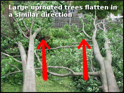
Microburst damage or strong wind gusts leave trees looking laid out or flattened, almost neatly in appearance. Larger uprooted trees lie in the same direction or fan-shaped pattern.
Tornado damage is much more chaotic, with large uprooted trees often crossing each other like pick-up sticks. Inspectors will likely also find signs of twisting in the trunks and root systems - when they can get to them.
Making a determination
All of the information collected by the survey team is coupled with additional data, such as weather radar history, satellite pictures of the area, and eyewitness accounts to make the final determination about what caused the damage.
If meteorologists believe a tornado caused the destruction, they will assign it a rating on the Enhanced Fujita Scale. The NWS will also issue a survey report that details the estimated wind speed of the storm, the length of the damage path, and the type of damage observed.
Usually, the entire damage survey process takes several days to complete. This is frustrating to the victims of the storm as the NWS’ determination impacts government recovery help. An accurate assessment, however, helps improve warning systems and have comprehensive reports for historical reference.
Sources: NWS


Comments